🚶 The signpost of distances
Curiosity
The signpost of distances
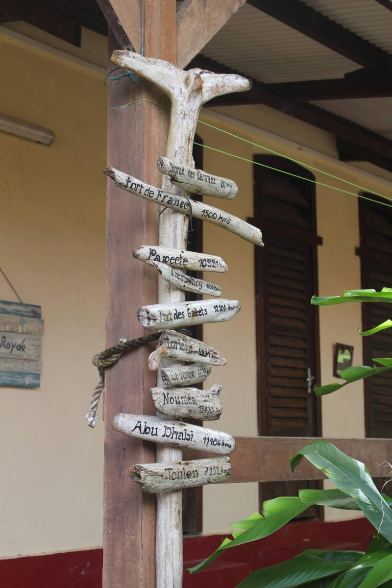
Photo taken in 2018: the place may have changed. Tap the photo to enlarge it.
On Île Royale, a driftwood signpost points to faraway towns and gives their distance. It shows how far these islands are from everything, and how far from home the convicts sent here were. Read it carefully: it hides a puzzle.
🔎 The signpost puzzle
Toulon, Cherbourg, Lorient, Île Longue, Fort-de-France, Papeete, Nouméa, Abu Dhabi… What do all these places have in common?
See the answer
They all host a port or base of the French Navy. Who made this signpost? We do not know yet.
🎧 Audio version in preparation
👨👩👧 Family challenge
On the signpost, which town is the nearest? And the farthest?
See the answer
The nearest: Dégrad des Cannes, the port of the Cayenne area (80 km). The farthest: Nouméa, in New Caledonia (15,420 km).
📍 Where to see it?
Under the veranda of a building on Île Royale (2018 photo, location to be found).
🗺 See on the mapFind out more
Displayed and verified distances
| Place | On the signpost | As the crow flies from Île Royale |
|---|---|---|
| Dégrad des Cannes (Guyane) | 80 km | 60 km |
| Fort-de-France (Martinique) | 1 500 km | 1 390 km |
| Île Longue (Finistère) | 6 633 km | 6 590 km |
| Lorient | 6 654 km | 6 630 km |
| Cherbourg | 6 868 km | 6 840 km |
| Toulon | 7 111 km | 7 090 km |
| Papeete (Polynésie française) | 10 924 km | 10 920 km |
| Abu Dhabi | 11 486 km | 11 460 km |
| Port des Galets (La Réunion) | 12 104 km | 12 070 km |
| Nouméa (Nouvelle-Calédonie) | 15 420 km | 15 420 km |
The straight-line distances were calculated by Karbet and rounded to the nearest ten kilometres. The signpost does not say how its own were measured; some worn inscriptions are hard to read.
🛠 Points to validate for this mock-up
- Exact location of the signpost and whether it is still there.
- Reading of the worn inscriptions (Lorient, Île Longue).
- Author and date of the signpost.